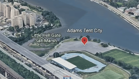


- Google Maps has created a surprising label for the location where New York City Mayor Eric Adams has decided to house asylum seekers in the city.
- Rather than reading ‘Humanitarian Emergency Response and Relief Center’ – as Adams called the soon to be opened center on Randalls Island – the website has the facility tagged as ‘Adams Tent City.’
- The tag appears when navigating over the northwest coast of the remote island between Manhattan and Queens, but is only visible when zoomed in to about 100ft above ground level.
Trending
Google Mock Maps NYC’s Illegal Migrant Dump As ‘Adams Tent City’